02 / Services
Geolocate · Survey · Digitise · Implement · Reconcile.
Consulting Engineers, Chartered Surveyors and Innovative Solutions — a faultless and strategic technical answer to the complex challenges of land development, construction and territorial management.
01 / Quality Manifesto
Excellence at the heart of every discipline.
Geolocate – Survey – Digitise – Implement – Reconcile
At NGOMEZ ENGINEERING, we don't just measure space — we structure, optimise and secure it. Driven by a pan-African vision of engineering, our purpose is to deliver a faultless and strategic technical answer to the complex challenges of land development, construction and territorial management.
Our strength lies in the perfect synergy between the legal rigour of the Chartered Surveyor, the strategic vision of the Consulting Engineer and the agility of new technologies.
Our Pillars of Expertise
- 01
Land and Topographic Expertise
Land is a capital asset that demands absolute legal and technical certainty. High-precision GNSS surveys, LiDAR, photogrammetry and bathymetry: we capture reality with millimetric accuracy to secure your investments.
- 02
Consulting Engineering and Works Supervision
A successful project starts with rigorous foresight. As Consulting Engineers, we support decision-makers, project owners and institutional partners — from feasibility studies to works supervision. We design durable infrastructure while optimising costs, schedules and resources.
- 03
Innovative Solutions Deployment
Innovation isn't optional, it's our standard. We embed digital transformation at the heart of our processes: GIS, 3D modelling, digital twins and applied AI for interactive, intelligent solutions tailored to tomorrow's realities.
Our Commitment: The NGOMEZ Pact
-
The Demand for Precision
We leave no room for approximation. Every data point captured, every drawing produced and every recommendation delivered is the result of rigorous quality control.
-
Integrity & Security
Bound by the strictest ethical standards of our profession, we guarantee the impartiality of our expertise and the absolute confidentiality of our clients' data.
-
Technological Agility
We invest continuously in training our talents and renewing our equipment to maintain our technological leadership in the field.
-
Lasting Partnership
We are not simple providers but strategic partners. Your success is the ultimate measure of ours.
02 / Our Practice Pillars
The unshakeable foundation of our expertise.
Three load-bearing piles form the unshakeable foundation of our expertise. Together they make up an integrated system able to meet any engineering, land, training or technological challenge. Our pillars are anchored in bedrock.
- 01 BECT
Consulting Engineers
Design Office & Topographic Controls
We support project owners from design to handover, with geometric controls and engineering studies of absolute rigour.
- Design studies
- Client representation (AMO)
- Works supervision
- Land development (urban, rural, agricultural, landscape)
- Sites (nuclear, oil, agro-industrial, railway…)
- Dams
- Substations
- Power lines
- Ports & airports
- Civil engineering structures
- Roads and motorways
- 02 CGEA
Chartered Surveyors · OGEC
Office of Accredited and Sworn Chartered Surveyors
We give territories a voice and decision-makers a vision. We measure the distance to the metre to help you take the leap.
- Expertise (land, real estate, judicial)
- Cadastre
- Land registration (direct, concession, partition, transfer)
- Transfers
- Co-ownership
- Interior surveys and division into volumes
- Subdivisions, partition and lotting
- Site condition reports & land/property development
- Withdrawal from undivided ownership
- Site and location plans (building permits)
- Cadastral plans
- 03 ISNIT
Innovative Solutions
Integrators of Smart, Digital and Technological Solutions
From geospatial added value to decision-making — the distance between information and action, we measure to the metre to help you take the leap.
- Artificial Intelligence
- LiDAR
- Radar
- Sonar
- Photogrammetry
- GNSS
- CIM / BIM
- Digital twins
- GIS / Webmapping
- Cartography & geomarketing
- Mobile mapping
- Bathymetry / hydrography
- Metrology / monitoring
- Network detection & georeferencing
- Drone / UAV platforms
Vision
« The Surveying Engineer — the Expert of measurement exactitude / of the exact measurement (precise and accurate). »
03 / Our Organisational Pillars
Five strategic pillars of excellence.
Our pillar-based organisation guarantees focused expertise and optimal coordination on every project. Each pillar concentrates specific skills to meet our clients' requirements with precision.
- Pillar 01
P2I
Engineering & Infrastructure
Design, technical studies and works supervision for major projects — roads, buildings, civil works, ports and airports.
- Pillar 02
PPT
Property Assets & Territories
Legal and technical safeguarding of land assets, territorial development, cadastral management and property valorisation.
- Pillar 03
PCM
Skills and Practices
HR development, professional training in geomatics and surveying, transfer of know-how and talent management.
- Pillar 04
PIA
Innovation and Artificial Intelligence
Integration of cutting-edge technology: drones, LiDAR, GIS, photogrammetry, digital twins and geospatial AI solutions.
- Pillar 05
PEI
Equipment & Investments
Instrument fleet management, investment in measurement equipment, technological renewal and optimisation of material resources.
04 / Our Areas of Intervention
360° expertise.
Five families of skills covering the full spectrum — from legal land advisory to high-end geospatial technology — to be your global strategic partner.
Secure your land assets, increase your heritage's value.
Secure your land assets, increase your heritage's value.
05 / Our Methodology
A rigorous architecture, a structured and transparent process.
Our rigorous, robust and effective method is deployed like an instrument set up in station, taking topographic data through multiple sightings. It rests on our 5 pillars of excellence, with a foundation set on bedrock made of our 3 piles (practice pillars).
- 1
Consultation
Analysis of your needs and definition of project objectives.
- 2
Quote
Detailed, transparent technical and financial proposal.
- 3
Data Acquisition
On-site intervention with the most modern equipment.
- 4
Processing & Modeling
Calculation, verification and quality control of the collected data.
- 5
Restitution & Delivery
Handover of the deliverables and post-mission support if needed.
06 / Our Equipment
Accurate measurements, exact results.
Our instrument fleet matches our ambitions: latest-generation equipment, regularly calibrated, to guarantee faultless measurements on every site. Each instrument is the safeguard of the trust you place in us.
- 05+
Laser Measurement — 3D Scanner + Rangefinders
Laser measurement instruments have revolutionised geospatial data capture by enabling precise, contactless measurements.
- 01+
UAV Measurement — LiDAR
High-density 3D point-cloud acquisition through low-altitude flight. Ideal for modelling complex sites, mines and corridors.
- 06+
UAV Measurement — Photogrammetry
Photogrammetric surveys for ortho-photos, DTMs and textured 3D models. Rapid coverage of large areas.
- 10+
Geodetic Instruments — GNSS Receivers
Dual-frequency high-precision receivers for centimetric positioning in RTK mode and differential post-processing.
- 03+
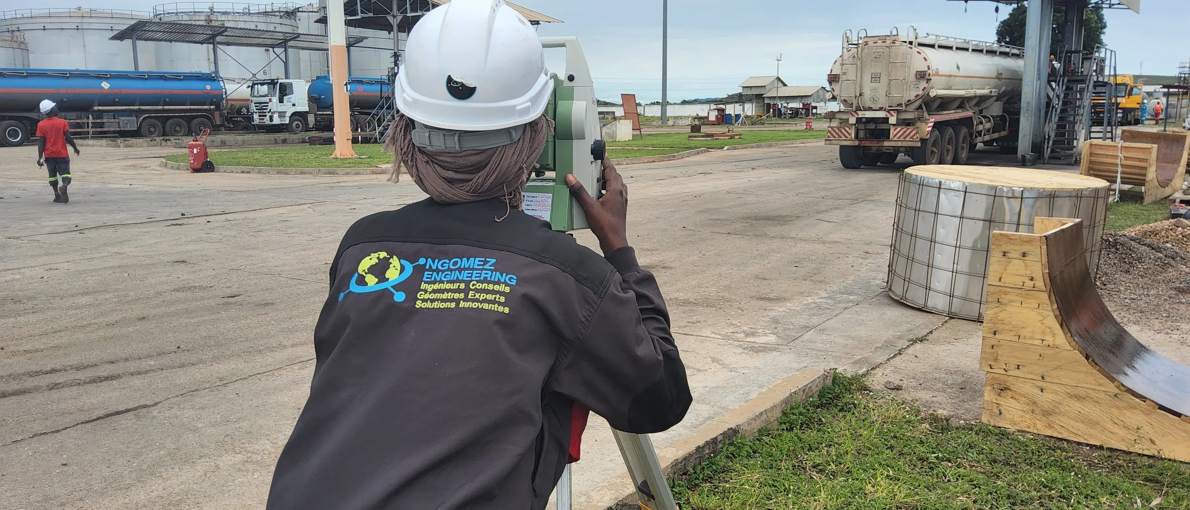
Topometric Instruments — Total Stations (TPS)
Millimetric angular and distance measurements for setting-out, surveys and structural controls.
- 06+
Topometric Instruments — Topographic Levels (LS)
Precision levelling for altimetry, settlement monitoring and altitude controls of civil works.
- 01+
Bathymetric Instruments — Echo Sounders
Acquisition of profiles of sea and river beds for bathymetry and hydrography.
- 10+
Accessory Instruments — Tripods
Wood, aluminium and carbon tripods for stable set-up of total stations, levels and GNSS receivers.
- 10+
Accessory Instruments — Pole Tripods & Bipods
Light supports for ranging poles and prisms in challenging field conditions.
- 20+
Accessory Instruments — Poles & Reflector Prisms
Single, triple and 360° reflector prisms for fast, continuous measurements in any terrain.
- 20+
Accessory Instruments — Communication & Field
Radios, ruggedised tablets and communication kits for on-site team coordination.
- 10+
Computing — Workstations
High-performance workstations for point-cloud processing, GIS and CAD.
07 / They trust us
50 referenced entities